Habitat Lab TopdownMap Visualization Examples
The example code below is available as a Jupyter notebook, or directly runnable via:
$ python path/to/habitat-lab/examples/tutorials/nb_python/Habitat_Lab_TopdownMap_Visualization.py
First, download (testing) 3D scenes:
$ python -m habitat_sim.utils.datasets_download --uids habitat_test_scenes --data-path data/
and point-goal navigation episodes for the test scenes:
$ python -m habitat_sim.utils.datasets_download --uids habitat_test_pointnav_dataset --data-path data/
Then import necessary modules:
import os
from typing import TYPE_CHECKING, Union, cast

import git
import matplotlib.pyplot as plt
import numpy as np

import habitat
from habitat.config.default_structured_configs import (
    CollisionsMeasurementConfig,
    FogOfWarConfig,
    TopDownMapMeasurementConfig,
)
from habitat.core.agent import Agent
from habitat.tasks.nav.nav import NavigationEpisode, NavigationGoal
from habitat.tasks.nav.shortest_path_follower import ShortestPathFollower
from habitat.utils.visualizations import maps
from habitat.utils.visualizations.utils import (
    images_to_video,
    observations_to_image,
    overlay_frame,
)
from habitat_sim.utils import viz_utils as vut

# Quiet the Habitat simulator logging
os.environ["MAGNUM_LOG"] = "quiet"
os.environ["HABITAT_SIM_LOG"] = "quiet"

if TYPE_CHECKING:
    from habitat.core.simulator import Observations
    from habitat.sims.habitat_simulator.habitat_simulator import HabitatSim

repo = git.Repo(".", search_parent_directories=True)
dir_path = repo.working_tree_dir
data_path = os.path.join(dir_path, "data")
output_path = os.path.join(
    dir_path, "examples/tutorials/habitat_lab_visualization/"
)
os.makedirs(output_path, exist_ok=True)
os.chdir(dir_path)
Below we define four example functions to show how to use Habitat’s visualisation functionality to draw a navigation episode bird-eye view and top-down maps.
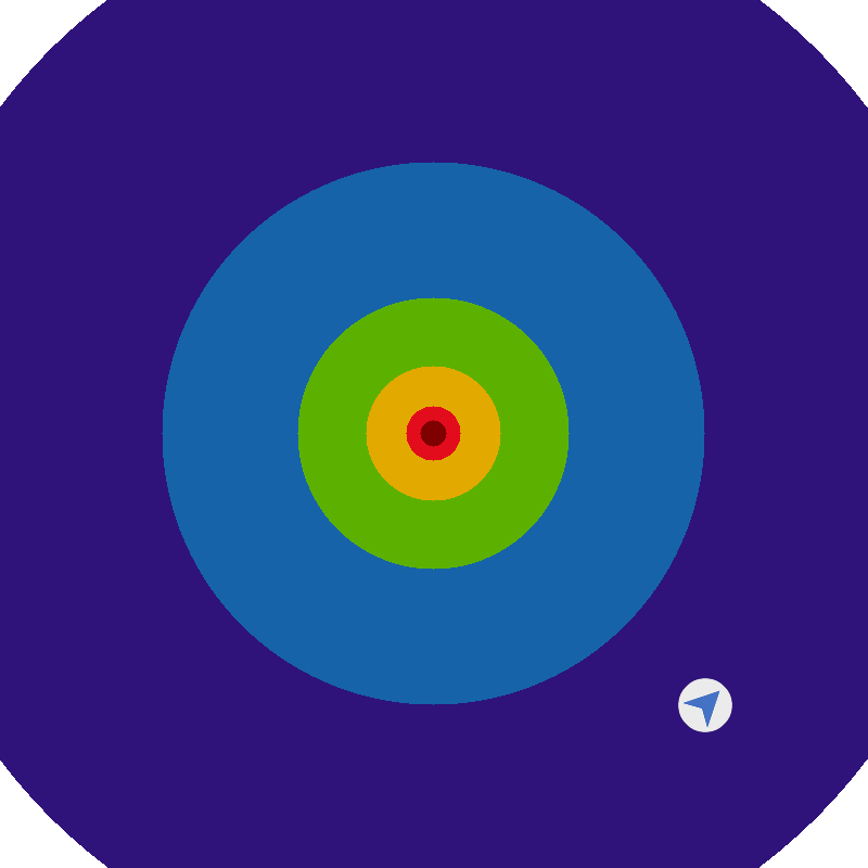
In the first example, a dummy episode birdseye view is drawn using habitat.utils.visualizations.maps.pointnav_draw_target_birdseye_view().
def example_pointnav_draw_target_birdseye_view():
    # Define NavigationEpisode parameters
    goal_radius = 0.5
    goal = NavigationGoal(position=[10, 0.25, 10], radius=goal_radius)
    agent_position = [0, 0.25, 0]
    agent_rotation = -np.pi / 4

    # Create dummy episode for birdseye view visualization
    dummy_episode = NavigationEpisode(
        goals=[goal],
        episode_id="dummy_id",
        scene_id="dummy_scene",
        start_position=agent_position,
        start_rotation=agent_rotation,  # type: ignore[arg-type]
    )

    agent_position = np.array(agent_position)
    # Draw birdseye view
    target_image = maps.pointnav_draw_target_birdseye_view(
        agent_position,
        agent_rotation,
        np.asarray(dummy_episode.goals[0].position),
        goal_radius=dummy_episode.goals[0].radius,
        agent_radius_px=25,
    )
    plt.imshow(target_image)
    plt.title("pointnav_target_image.png")
    plt.show()
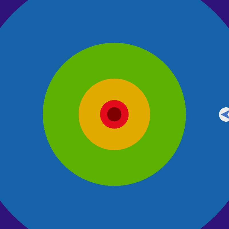
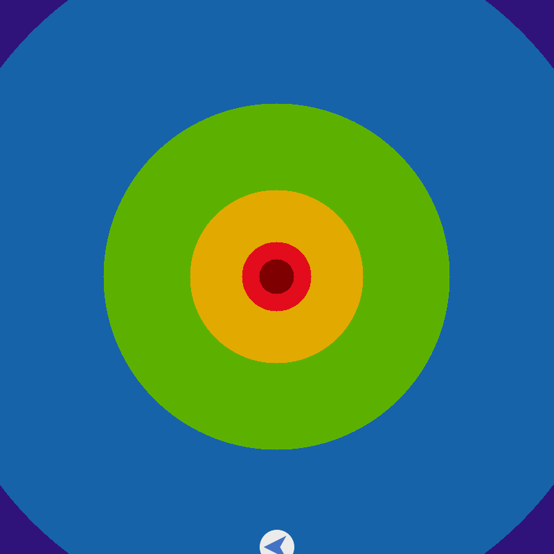
The procedure is repeated in the second example, with the agent initialized at four different borders.
def example_pointnav_draw_target_birdseye_view_agent_on_border():
    # Define NavigationGoal
    goal_radius = 0.5
    goal = NavigationGoal(position=[0, 0.25, 0], radius=goal_radius)
    # For defined goal create 4 NavigationEpisodes
    # with agent being placed on different borders,
    # draw birdseye view for each episode and save image to disk
    ii = 0
    for x_edge in [-1, 0, 1]:
        for y_edge in [-1, 0, 1]:
            if not np.bitwise_xor(x_edge == 0, y_edge == 0):
                continue
            ii += 1
            agent_position = [7.8 * x_edge, 0.25, 7.8 * y_edge]
            agent_rotation = np.pi / 2

            dummy_episode = NavigationEpisode(
                goals=[goal],
                episode_id="dummy_id",
                scene_id="dummy_scene",
                start_position=agent_position,
                start_rotation=agent_rotation,  # type: ignore[arg-type]
            )

            agent_position = np.array(agent_position)
            target_image = maps.pointnav_draw_target_birdseye_view(
                agent_position,
                agent_rotation,
                np.asarray(dummy_episode.goals[0].position),
                goal_radius=dummy_episode.goals[0].radius,
                agent_radius_px=25,
            )
            plt.imshow(target_image)
            plt.title("pointnav_target_image_edge_%d.png" % ii)
            plt.show()
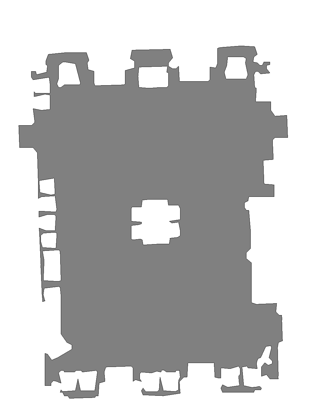
Third example shows how to use habitat.utils.visualizations.maps.get_topdown_map_from_sim() to get top-down map from Simulator instance (of type habitat.sims.habitat_simulator.habitat_simulator.HabitatSim).
def example_get_topdown_map():
    # Create habitat config
    config = habitat.get_config(
        config_path=os.path.join(
            dir_path,
            "habitat-lab/habitat/config/benchmark/nav/pointnav/pointnav_habitat_test.yaml",
        )
    )
    # Create dataset
    dataset = habitat.make_dataset(
        id_dataset=config.habitat.dataset.type, config=config.habitat.dataset
    )
    # Create simulation environment
    with habitat.Env(config=config, dataset=dataset) as env:
        # Load the first episode
        env.reset()
        # Generate topdown map
        top_down_map = maps.get_topdown_map_from_sim(
            cast("HabitatSim", env.sim), map_resolution=1024
        )
        recolor_map = np.array(
            [[255, 255, 255], [128, 128, 128], [0, 0, 0]], dtype=np.uint8
        )
        # By default, `get_topdown_map_from_sim` returns image
        # containing 0 if occupied, 1 if unoccupied, and 2 if border
        # The line below recolors returned image so that
        # occupied regions are colored in [255, 255, 255],
        # unoccupied in [128, 128, 128] and border is [0, 0, 0]
        top_down_map = recolor_map[top_down_map]
        plt.imshow(top_down_map)
        plt.title("top_down_map.png")
        plt.show()
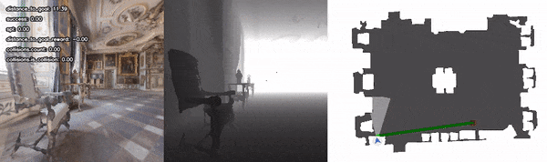
The last example defines ShortestPathFollowerAgent that extracts the actions on the shortest path to the goal. This agent is launched in the simulation environment to navigate to the target location specified in the first habitat test scenes navigation episode. Agent’s observations and images from habitat.tasks.nav.nav.TopDownMap measure are collected along the trajectory and further used to generate and display navigation video.
class ShortestPathFollowerAgent(Agent):
    r"""Implementation of the :ref:`habitat.core.agent.Agent` interface that
    uses :ref`habitat.tasks.nav.shortest_path_follower.ShortestPathFollower` utility class
    for extracting the action on the shortest path to the goal.
    """

    def __init__(self, env: habitat.Env, goal_radius: float):
        self.env = env
        self.shortest_path_follower = ShortestPathFollower(
            sim=cast("HabitatSim", env.sim),
            goal_radius=goal_radius,
            return_one_hot=False,
        )

    def act(self, observations: "Observations") -> Union[int, np.ndarray]:
        return self.shortest_path_follower.get_next_action(
            cast(NavigationEpisode, self.env.current_episode).goals[0].position
        )

    def reset(self) -> None:
        pass


def example_top_down_map_measure():
    # Create habitat config
    config = habitat.get_config(
        config_path=os.path.join(
            dir_path,
            "habitat-lab/habitat/config/benchmark/nav/pointnav/pointnav_habitat_test.yaml",
        )
    )
    # Add habitat.tasks.nav.nav.TopDownMap and habitat.tasks.nav.nav.Collisions measures
    with habitat.config.read_write(config):
        config.habitat.task.measurements.update(
            {
                "top_down_map": TopDownMapMeasurementConfig(
                    map_padding=3,
                    map_resolution=1024,
                    draw_source=True,
                    draw_border=True,
                    draw_shortest_path=True,
                    draw_view_points=True,
                    draw_goal_positions=True,
                    draw_goal_aabbs=True,
                    fog_of_war=FogOfWarConfig(
                        draw=True,
                        visibility_dist=5.0,
                        fov=90,
                    ),
                ),
                "collisions": CollisionsMeasurementConfig(),
            }
        )
    # Create dataset
    dataset = habitat.make_dataset(
        id_dataset=config.habitat.dataset.type, config=config.habitat.dataset
    )
    # Create simulation environment
    with habitat.Env(config=config, dataset=dataset) as env:
        # Create ShortestPathFollowerAgent agent
        agent = ShortestPathFollowerAgent(
            env=env,
            goal_radius=config.habitat.task.measurements.success.success_distance,
        )
        # Create video of agent navigating in the first episode
        num_episodes = 1
        for _ in range(num_episodes):
            # Load the first episode and reset agent
            observations = env.reset()
            agent.reset()

            # Get metrics
            info = env.get_metrics()
            # Concatenate RGB-D observation and topdowm map into one image
            frame = observations_to_image(observations, info)

            # Remove top_down_map from metrics
            info.pop("top_down_map")
            # Overlay numeric metrics onto frame
            frame = overlay_frame(frame, info)
            # Add fame to vis_frames
            vis_frames = [frame]

            # Repeat the steps above while agent doesn't reach the goal
            while not env.episode_over:
                # Get the next best action
                action = agent.act(observations)
                if action is None:
                    break

                # Step in the environment
                observations = env.step(action)
                info = env.get_metrics()
                frame = observations_to_image(observations, info)

                info.pop("top_down_map")
                frame = overlay_frame(frame, info)
                vis_frames.append(frame)

            current_episode = env.current_episode
            video_name = f"{os.path.basename(current_episode.scene_id)}_{current_episode.episode_id}"
            # Create video from images and save to disk
            images_to_video(
                vis_frames, output_path, video_name, fps=6, quality=9
            )
            vis_frames.clear()
            # Display video
            vut.display_video(f"{output_path}/{video_name}.mp4")